The 2020 East Troublesome Fire: What may have happened if there had been one more windy day?
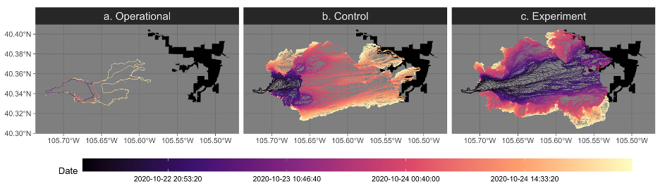
Wildfire burned area and severity have been increasing in the Western United States since the 1980s. In Colorado, wildfires during downslope wind events such as the 2020 East Troublesome Fire can spread quickly, surprising communities in their paths. Using operational fire perimeters from the National Interagency Fire Center, we estimated that the 2020 East Troublesome Fire spread at an average speed of 2.7 km per hour on its fastest run prior to crossing the Continental Divide on a path towards Estes Park, Colorado. Congested traffic jammed highways leading out of Estes Park during evacuations, but changing weather conditions impeded the fire’s progress into town.
We explored what may have happened if there had been another day of wind speeds exceeding 60 km per hour (or equivalently, an ignition near the Continental Divide on October 21, 2020). We used the Weather Research and Forecasting-Fire model (WRF-Fire) to simulate the ignition after the fire spotted over the Continental Divide for historical conditions and one more windy day. We also modeled evacuations for two idealized scenarios. We found that another windy day may have caused the fire to reach town within nine hours compared to the seven hours needed to evacuate the town during stop-and-go traffic conditions. This means that an evacuation order would have needed to be ordered, understood, and followed within two hours of ignition. By investigating what may have happened, we aimed to improve our understanding of entrapment risk among mountain towns increasingly affected by fast wildfires.