Fast fires
When it comes to wildfire danger, speed – not size – is the real threat to communities and infrastructure. Despite being relatively rare, fast-moving fires caused 88% of fire-related damages in the Western U.S. between 2001 and 2020. These blazes spread rapidly, launching embers ahead of the flames and igniting homes before responders can act.
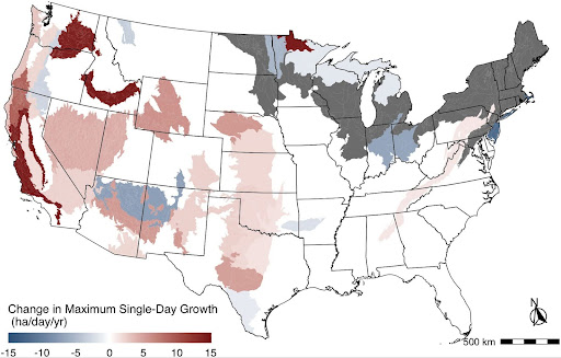
Fire growth rates have surged 250% in just two decades, and with continued warming, the frequency of fast fires could increase by 50–200%. Yet, current wildfire risk models fail to account for fire speed, focusing only on area burned, intensity, and probability. This gap in risk assessment is a critical management issue because when it comes to protecting lives and property, how fast a fire spreads matters more than how big it gets.
We created FIREDpy (FIRe Event Delineation for python), an algorithm that tracks daily fire growth rates using NASA’s Moderate Resolution Imaging Spectroradiometer (MODIS) Burned Area Product. By combining this data with wildland-urban interface (WUI) expansion, we can assess community exposure to fast-moving fires. Our research highlights the economic, ecological, and societal stakes from the destruction of forests, watersheds, and wildlife habitats to critical policy implications for insurance, zoning, evacuation planning, and fire management.
See our recently published article in Science and a short video from PBS Terra for more information on fast fires.
Fast Fire Network
Wildfire risk in the western U.S. is changing—not just because fires are getting larger, but because they are moving faster. The Fast Fire Network is an NSF-funded, cross-sector collaboration focused on understanding and reducing the risks posed by fast-moving wildfires, which are disproportionately responsible for loss of life and homes in the wildland–urban interface. The Fast Fire Network brings together fire scientists, social scientists, data scientists, practitioners, and industry partners to develop a new fast fire risk framework that integrates fire speed, human exposure, and social and structural vulnerability. Through open data, AI-enabled tools, hackathons, working groups, and stakeholder-driven forums, the Fast Fire Network is building actionable, data-driven solutions to protect communities. We are actively seeking collaborators across disciplines and sectors who want to help redefine wildfire risk and co-produce science that saves lives and property.
If you are interesting in contributing to the Fast Fire Network, visit https://tinyurl.com/fast-fire-network to fill out an interest form. We are looking forward to hearing from you!